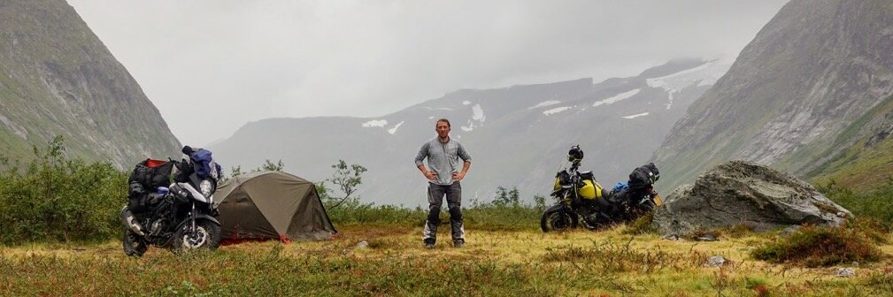
Exploring the wilderness is something I love to do in all shapes and forms and often we take our motorcycle to remote destinations to escape from it all. How do you get there and back when there is no phone service? Let me give you my best advice.
What is the best GPS app for off roading?
- Maps.me
- Gaia GPS
- ExplorerOz Travel
In this article I will discuss why I think these apps are great and why you should try them.


Assumptions about offroad navigation
For this article I am basing my advice on the assumption that you are planning to use any type of motorised vehicle. This is important because apps that are targeted for hikers or bicyclist will suggest routes that are not allowed or suitable for these types of transportation therefor will be omitted from this list.
I’m also assuming you are really into offroading and not overlanding (in the long term, intercontinental sense of the word). Meaning that you will spend most of your time following tracks that you created or downloaded and not roads in far away foreign countries. If the latter is your plan, my advice is to stick with google maps or maps.me. That is what I did and it got me to the other side of the planet twice.
But the most important piece of advice I have for you, before diving into a detailed list, is which app is best for you depends on what you like. So try them out, and works best for you.
What does an offroad navigation app has to have?
Two important elements that an offroad vehicle navigation app should do are:
- Offline maps
- Tracking where you’ve been
- Rich map data that extends beyond the standard road system of the places you want to travel
Each of the apps mentioned in this article has at least these three features. However, on some of these apps you will need to pay either a membership fee or once off. And some apps will charge you more for different map layers with extra information such as National Park borders or private land borders. This type of information is very regional therefor I’ve grouped the apps by geographical focus:
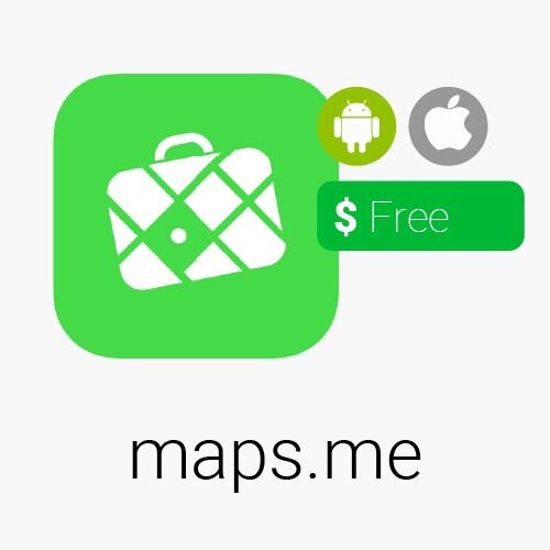
Fast, detailed and entirely offline maps with turn-by-turn navigation, based on Open Street Map data (OSM). The great thing about maps.me is that they use vector based maps, meaning you can zoom in forever and never see a single pixel.
Because it is based on OSM data, which is open-source and collected by map enthusiasts around the world, even the smallest footpaths can be found on these maps.
It is easy to select different regions or whole countries to download when you are online so that once you start exploring, you have all the maps you need right there in your pocket.
Another great feature is the snail trail, is the ability to leave a trail on the map where you’ve been and track back the same way.
But most importantly, all these functionalities are for free. And that cannot be said of some of the other apps on this list. Off course it won’t be the best, especially when it comes to different map layers but none of the other maps can beat this price.
What users are saying
Finally 5 stars
This app is my favourite navigation vehicle. Recently introduced altitude lines make it a sound competitor to specialised trekking apps. Only a few countries like China and Switzerland have more detailed off road maps available. In Africa, topographical details are plentiful but the overall navigation is a bit difficult. Worldwide, in cities and densely populated areas I still need to use the main competitor to get the whole picture. However, the app has been improving constantly. Pins and bookmarks are easy to put and to edit. It is available off line. It contains an amazing amount of off road details, even if they are not always completely described and searchable. It is the ultimate global navigation app for outdoor activities.
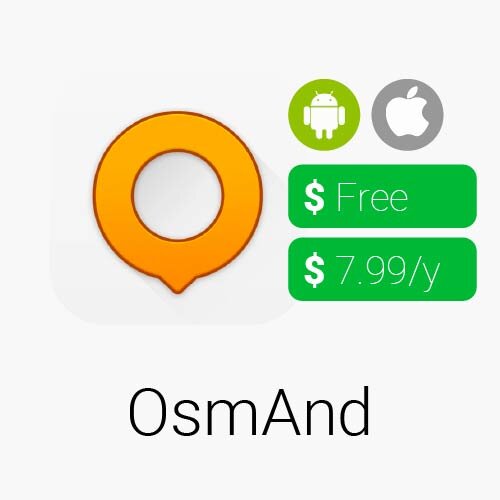
OsmAnd Maps is a map application with access to free, worldwide, and high-quality OpenStreetMap (OSM) data (the same as maps.me). All map data can be stored on your device's memory card for offline use. All the main functionality works both online and offline (no internet needed).
It has some great features that are specifically useful for offroading although most of these are not available in the free version. The contour lines and hill shading make exploring in the mountains much more intuitive. (not available in the free version).
OsmAnd can display different overlays like touring/navigation GPX tracks and additional maps with customizable transparency.
For car navigation, vehicle parameters and specifications can be entered which is great for RVs and expedition trucks and optional speed and altitude display. Lastly it has an option to FAVOUR (rather than avoid) unpaved roads (remember when you have this selected!). How cool is that! The only reason it is in second place for me is because of its price, off-roading and overlanding is expensive enough, so if you are happy using maps.me then perfect, if not then give OsmAnd a try!
What users are saying
Great for turn-by-turn nav on custom routes
If you’ve been looking for an app that supports turn-by-turn (including voice) navigation for custom routes, OsmAnd delivers! I had tried many apps, including all the big names in maps and navigation, but none could do what OsmAnd does. I was looking for an app to find off-road routes between destinations and it does this with the flip of a single button. No more choosing “fake” interim destinations to force a specific route. If you want to avoid specific roads that the other switches don’t handle, you can just tap any road (or multiple roads) and your route will not use them. Great app!
Avenza Maps is a mobile map app that allows you to download maps for offline use on your iOS and Android smartphone or tablet. You might not really call it a navigation app but it is really good but there are people out there who love it.
It is like a digital map store, with the biggest collection of maps. You can easily browse and purchase maps from all over the world using the convenient Avenza Map Store.
Use your device's built-in GPS to track your location on any map. Plot and record information about locations, import and export placemarks, measure distance and area, and even plot photos.
The downside of this app is that is doesn’t do turn by turn navigation, therefor you can really only use it for tracking and pin pointing yourself on the map, tracking and logging your trip. It won’t tell you where to go.
What users are saying
A Must Have
I absolutely love this app. My family enjoys , biking, and off highway motorcycle riding which is where this app excels. For all you single track and trail riding motorcycle enthusiasts find your map by searching for either “MVUM” (multi vehicle use map) and/or “OHV” (off highway vehicle). No worries about cell service as this app utilises the GPS in your phone. I also love the ability to plot photos and mark my trails which makes it a joy to share later with friends.
4. Locus Maps
free with ads, silver $10/year, gold $24/year | Android | 4.5 star rating
Multifunctional navigation app with offline maps for a fully enjoyable outdoor experience. Create, plan, edit, record, save or share your trips, keep the memories, track your performance, and much more. Locus Map is designed for hiking, mountain biking, cycling, running, geocaching, cross-country skiing, and other outdoor activities. Fully customizable and flexible, offering a wide range of cool functions running above a variety of maps of the whole world.
Navigate and guide offline:
- turn-by-turn voice instructions or sound signals
- out-of route alert
- navigation and guidance along routes imported from elsewhere
- beeline guidance in an open terrain
Outdoor maps by the world’s best cartographic publishers
- USA&Canada - USGS classic/satellite, AccuTerra trail maps, BackRoad Map Books,
- Europe - Ordnance Survey (UK), Kompass, Outdooractive, Freytag&Berndt (Germany, Austria, Italy), IGN (France, Belgium), CNIG (Spain), Lantmäteriet (Sweden), Kortforsyningen (Denmark), PZS (Slovenia), Compass (Poland), Swisstopo (Switzerland), SHOCart (Czechia, Slovakia) and many others...
What users are saying
Love this app
An excellent navigation app for both on and off the road. I tried it out, taking my motorcyle on a 462 mile route that I imported from GPX file created by another app. It had hundreds of waypoints and thousands of location points spanning the entire length of New Jersey. Both on-road and off-road section showed up as well as showing hiking trails along the way. Great for overland adventures.
Navigate, track, and explore with Gaia GPS. Millions of people worldwide have used Gaia GPS to hike, hunt, camp, ski, and explore the backroads.

Gaia GPS helps you find a campsite on the road, or deep in the backcountry. As a camping app, Gaia GPS delivers public land data to help you stay legal, maps with campsites, parks, and forests, as well as weather overlays. Mark waypoints to create custom camping maps, plus reference road maps and Motor Vehicle Use Maps (MVUM) to plot overland, 4x4, and off-roading routes. Use Gaia GPS in your car's dash via Apple CarPlay.
Free - Use all features, except you can't mass-download maps for offline use, and you can't access all the complete maps catalog. Free maps include Gaia Topo, Native Lands, Air Quality, and Wildfires.
Premium Membership - Access and download a worldwide catalog of maps. You get access to these map sources, plus many more.
- NatGeo Trails Illustrated (including Appalachian Trail, Colorado Trail, and John Muir Trail maps)
- ESRI World Satellite Imagery
- NOAA weather forecasts
- US Private Land Ownership (including owner names and addresses for parcels)
- US Hunting Layers
- US Public Land (BLM, Forests, more)
- US Motor Vehicle Use Maps (MVUMs)
- Historical Wildfires
- Hill-shading, contour-line, slope-angle, and other overlays
- Backroads Mapbooks Canada
- France IGN
- Swiss Topo

What users are saying
Great to plan routes for off-road riding
Downloaded the app and tested it for off-road motorcycle. The automatic tracing of a route over existing marked trails is an awesome feature that makes planning the route considerably easier than with Google Earth or Garmin Basecamp. I downloaded satellite image and usgs topo maps of the area I was riding in so I didn't need to rely on having network or not during the ride. Compared to a Garmin gps unit the only limitation is the device's gps accuracy and recording rate but it's no issue for off-road riding/driving, likely not an issue for hiking neither.
OnX Offroad is the only app on this list so far that specifically targets offroad vehicle navigation. Next to that is shares popular trails on the map so you don’t have to plan your own and this time around you can just start navigating instead of having to check if it is a hiking trail or not. With more than 985 Million acres of public land and 550,000+ miles of open roads and trails including open dates and width restrictions, onX Offroad is a must-have app for any motorized enthusiast.
Know before you go with the most trusted and accurate GPS satellite / topo trail mapping app. Turn your phone into the best off-road mapping tool for finding open dirt roads and trails, tracking your favorite routes and making custom waypoints along the way. Works using your phone’s GPS when you’re off-grid and offline—with full detail satellite imagery, open trails and remote campsites all while out of cell service.
Gives you more time enjoying the ride and less time on rides that end in a locked gate. If you dirt bike, enduro, moto, adventure bike, ATV, side by side, UTV, SxS, 4X4, wheel, rock crawl, mud, overland or drive dirt roads in your truck, this is the best OHV/ORV app for you.
What users are saying
Best overland platform
Today I got back from a multi-day overland trip that took place near San Diego, CA. I used this app to plan the entire route for the trip as well as to see where I was going. The fact that it has thousands of trails already marked makes it very easy to plan a route. Many trails even have a ton of information about them included when you tap them. Even when there’s trails not ‘officially’ marked, it still has most marked as single/dual tracks. You can add different types of markers and waypoints when planning a long trip, which is very useful as they can become very clustered sometimes. Downloading offline maps has never been easier as well. Just pick an area on the map and boom. In my opinion, best off-road/overland maps platform out there. Far easier to use than popular competitors. Definitely made the annual subscription worth it!
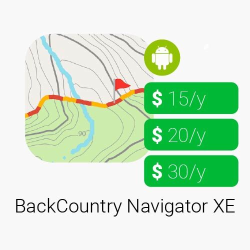
3. BackCountry Navigator XE:Outdoor GPS Topo App
$15/year, $20/year, $30/year | Android | 4.3 star rating

Download and use topo maps offline to explore the outdoors using your smartphone! Use the GPS in your smartphone to navigate, mark your path and record waypoints.
Look at the advantages that BackCountry Navigator XE brings to the table. Easy Grid Based Download of Maps Vector Topo Maps for the World GPS Navigation Planning In The Cloud
What users are saying
It keeps getting better
I have been using this app since it was first released as bata and have watched it steadily improve. There is great map support and I love the online storage for my trips. As an added bonus it works well on my Chromebook which I use to preplan my ATV rides. I look forward to watching this app grow as new features are added.
What is great about this app, is that it is specifically targeted towards Australia and has all the local maps you need. It is expensive, so you might want to try a free version of one of the world wide oriented apps.
Australian travel app for camping, caravanning, and four wheel driving with maps, tracking and navigation tools. Easy to use. Australian-made. For use online or offline. Ideal for 4WD adventures. POIs & Treks included. Includes EOTopo 2021 maps - online & offline. Turn-by-turn navigation, trip planning, mapping, snail trail, and tracking.
Maps & navigation fully functional when offline Snail Trail plots a line on map to help you backtrack Create auto-routed navigation 191 ExplorOz Treks provided incl. 4wd tracks & deserts Can upload track files as GPX for use as Track Logs
What users are saying
Great for remote travel
Great app and in conjunction with the EO toppo high resolution maps is all the mapping needed for remote travel.
The inbuilt access to the Explore Oz database of treks and places along with the ability to record routes taken and the ability to have up to date or cached route uploaded to web mapping, when in cellular range, for friends and family to follow the progress of a trip.
I was even able to get full functionality using an external bluetooth GPS, on a WiFi only iPad, after receiving prompt support from EO development team giving clear and easy directions on how to modify settings from within the app itself.
Love the whole package..
The Hema 4X4 Explorer App has been developed to allow users to plan, navigate and share their remote trips with ease and confidence. Whether it is an offroad 4WD Adventure, a remote camping trip or a lap around Australia, the 4X4 Explorer app is your perfect travelling companion.
Explore over 690,000kms of 4WD tracks and 545,000km of unsealed roads featured on the Hema Map. Access over 100,000+ points of interest (POI) including 40,000 Hema verified campsites, caravans parks, dump points, lookouts, national parks and much more.
4X4 explorer is not designed for turn by turn navigation and should be used as a guide only.
What users are saying
Very promising!!!
I predominantly use the Hema apps (Explorer and 4x4 Explorer) on a phone while travelling. This new app is a big step forward. The previous Explorer as are the other Hema products are raster maps which presents a few problems when used on a small screen. Therefore a vector based app like this new 4x4Explorer app is a welcome addition. It is always crystal clear, gives more info about campsites and other features.
Save on Pinterest
Conclusion
Whatever your preferences are, I’m sure there is the right navigation app out there for you. Traveling with a phone or tablet for navigation is just so much more efficient than using a dedicated gps device. Whichever app you end up with, remember that getting out there is more important then getting all the best equipment.
Stay safe!
Leave a comment down below
What is your favourite offroad navigating app?


Frequently Asked Questions
Below I will answer some related frequently asked questions.
Can you use Google Maps for offroading?
Not really, even though Google Maps is available offline it is not very convenient. Nor does it offer detailed topographical maps or allow you to track your route. There are better, also free, option out there.
What is the best off road GPS app for iPhone?
Which app is the best depends on your style of navigating while driving offroad. For iPhone users the best app for offroad navigation which gives turn by turn instructions is OsmAnd. It has many features that are delightful when driving offroad.
Is OnX offroad worth it?
That really depends on which state you live in because the content is not evenly divided across the country. Outside of the USA it is pretty much useless and not worth the money. But with the 7 day free trial you can always try it out in your local area.
Which is better onX or Gaia?
Gaia GPS is still the winner when it comes to offroad navigation. It has way more map layers available which are crucial in planning any adventure. As well as downloading map sections for offline use is much simpler in Gaia GPS.
What is the best off road trail map app?
The best offroad trail map app is Avenza maps. It is a digital map store where you can buy the widest selection of maps to be downloaded into the app and used whenever you need them. If you are looking for easy trails to follow check out gaia.gps or onx offroad.
What is the best app for overlanding?
Without a doubt the best app for overlanding is iOverlander. No serious overland can live without it. It has all the details when it comes to campsites, border crossings and road conditions.